Showing 37 items matching measuring angles
-
 Federation University Historical Collection
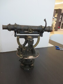
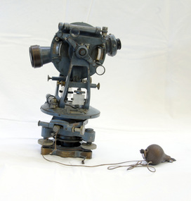
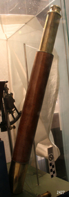
Scientific Instrument, Theodolite: Early 1900s, c1860
... measuring angles...The theodolite is used in surveying and measures vertical... ballarat school of mines flavelle bros & co measuring angles road ...The theodolite is used in surveying and measures vertical and horizontal angles. Placed on a tripod, it is used to find angles in road building, tunnel alignment and other civil-engineering work. The theodolite was used at Ballarat School of Mines in the surveying course. It is possible that this instrument was imported by Flavelle Bros & Co having been made to their order by a European instrument makerTheodolite (without a matching tripod) with four leveling screws at the base. Telescope not fully rotatable, ends can be interchanged. Underslung levelling bubbletheodolite, surveying, european instrument, importers, ballarat school of mines, flavelle bros & co, measuring angles, road building, civil engineering -
 Stawell Historical Society Inc
Instrument - Realia, Total Internal Reflection Apparatus, 1960's
... Use to measure angle of total internal reflection of light...Use to measure angle of total internal reflection of light ...Use to measure angle of total internal reflection of light. Used at Stawell Technical SchoolGrey box for liquid with glass slide on rotating scaleMade in Australia for H.B. Selby & Co Pty Ltd Analite Pty Ltdscience, education -
 Queenscliffe Maritime Museum
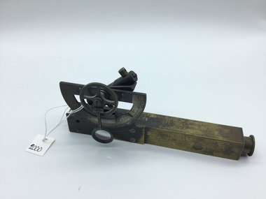
Tool - Inclinometer, M.V. Australian Explorer
... An inclinometer measures the angle of inclination.... Triangular timber shape with curved base. Brass measuring plate ...An inclinometer measures the angle of inclination of a vessel or aircraft to the horizontalTimber and brass inclinometer from the M.V. Australian Explorer. Triangular timber shape with curved base. Brass measuring plate with measurements from 0-40 degrees on each side. Brass pointer indicates angle of inclination of vessel. 'EIWA' label on front. '87-156' inscribed in pen on back and underside. navigational instruments, australian explorer -
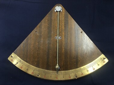
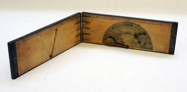 Orbost & District Historical Society
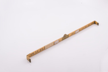
clinometer rule, mid 19th -earl 20th century
... instrument used in surveying to measure vertical angles. It is used... instrument used in surveying to measure vertical angles. It is used ...This clinometer, is a hand-held optical scientific instrument used in surveying to measure vertical angles. It is used to measure the angle of elevation from the ground in a right-angled triangle. It may have been used by a surveyor or a forester to measure the height of tall things where you couldn't possibly reach to the top of e.g. flag poles, buildings or trees.This item is an example of an early hand held measuring instrument.. Today the use of electronic sensors is an important component in the design and function of the clinometers.A rectangular wooden folding measuring instrument. the panels are brass framed. Inside is a brass semi-protractorgraduated 90-0-90' with index arm pointeran dwith a graduated edge in inches. Outside is a temperature conversion scale,Troughton & Simms, LONDONscientific-instrument measurement clinometer -
 Flagstaff Hill Maritime Museum and Village
Instrument - Octant, mid 1800's
... . The primary use of an Octant is to measure the angle between...) eyepieces. Scale attached for measuring angles. Label inside... attached for measuring angles. Label inside the fitted, wedge ...An Octant is a doubly reflecting navigation instrument used primarily by sailors to measure the angular distance between two visible objects and was a forerunner of the sextant. The name comes from the Latin octo, or "one-eighth of a circle," for the Octan'ts arc which spans 45°, or one-eighth of a circle. The primary use of an Octant is to measure the angle between an astronomical object and the horizon for celestial navigation. The estimation of this angle, is known as sighting or shooting the object, or taking a sight. The angle, and the time when it was measured, can be used to calculate a position line on a nautical chart (latitude), for example, sighting the Sun at noon or Polaris at night (in the Northern Hemisphere) gives an angle by which the latitude can then be estimated. Sighting the height of a landmark on land can also give a measure of distance. This fine octant once belonged to Captain Farquhar Chisholm and was donated by his granddaughter, Margaret Ruth Greer (nee Chisholm, born 1914). The label inside the Octant's box reads “Thomas L. Ainsley, Instrument Maker … etc”. Farquhar Chisholm was born in 1832 in Inverness, Scotland. He regularly sailed on perilous voyages between Quebec, Canada and the Baltic ports of Europe. In 1854 he migrated to Australia during the Gold Rush, to a place called Fiery Creek (near Beaufort Victoria) where he was fairly successful in his quest for gold. In the years of the Great Gold Rush, it was said that there were over 40,000 diggers in the goldfields of the Beaufort area! In 1857 having made sufficient money, he hired another crew and returned to Clachnacuddin, Inverness shire, Scotland and in that same year, he studied and obtained his Master Mariner Certificate (which would have included the use of an octant for navigation). He was appointed to Mr George (or James) Walker, as commander of his sailing ship, the 3-masted ELIZABETH, built 1859 and known as “The Walker barque”. In 1870 he married, then in 1887 returned to Australia with his wife and children (Kenneth Chisholm (1871), Mary Bremner Chisholm (1873), Margaret Hood Chisholm (1874), Farquhar Chisholm (1878)). They arrived in Port Melbourne, Victoria and sadly, only six weeks after landing, his wife Caroline passed away (in Geelong,1888). In 1900 Capt. Chisholm lived in Camperdown (Victoria) and not long after this his daughter Margaret died of consumption. In his later years, he went to live in the manse of St. Paul’s Presbyterian Church, Wangaratta, with his son, Rev. Farquhar Chisholm. He died there on Sat, 23rd March 1912, 80 years old. He was known as “… quiet, unobtrusive and competent, respected by all with whom he came in contact”. Some other members of Captain Chisholm’s family are; his older son Kenneth Chisholm, who was a contractor in Camperdown; a nephew Donald Macintosh (of 23 Douglas Row, Inverness); a grandson Brian Jones (son of Caroline Belle-Jones nee Chisholm, who lived in Camperdown in the earlier part of her life).The octant, the forerunner of the sextant, was a significant step in providing accuracy of a sailors latitude position at sea & his vessels distance from land when taking sightings of land-based landmarks.Octant, once belonging to Captain Farquhar Chisholm. Wedge shape (the size of an eighth of a circle), made of wood, glass and metal. Used in the 1880s. Maker’s name across centre “L. SIMON - - - SHIELDS”. Three (3) light filtering, coloured glass shades. Two (2) eyepieces. Scale attached for measuring angles. Label inside the fitted, wedge-shaped case "Thomas L. Ainsley, Optician"Label inside case "Thomas L. Ainsley, Optician" Maker’s name across centre “L. SIMON - - - SHIELDS”.flagstaff hill, warrnambool, shipwrecked-coast, flagstaff-hill, flagstaff-hill-maritime-museum, maritime-museum, shipwreck-coast, flagstaff-hill-maritime-village, maritime navigation, navigation instrument, migration, captain chisholm, farquhar chisholm, sailing ship, the elizabeths, thomas l. ainsley, l. simons, shields england, octant, john hadley, chisholm -
 Orbost & District Historical Society
theodolite, first half 20th century
... is a precision instrument for measuring angles in the horizontal... to measure horizontal and vertical angles by surveyors since ...Theodolites have been used to measure horizontal and vertical angles by surveyors since the 1500s. A theodolite is a precision instrument for measuring angles in the horizontal and vertical planes. Theodolites are used mainly for surveying applications, and have been adapted for specialized purposes in fields like meteorology and rocket launch technology. Theodolites, such as this one, were instrumental to early surveyors, and would have played a significant part in their everyday work. The plumb bob was used to set the instrument exactly over a fixed survey marker.This theodolite was made by Troughton and Simms, who were significant scientific instrument makers of the 19th century and early 20th century. In 1782 John Troughton purchased Benjamin Cole's shop in Fleet Street, London enabling him to sell his own signed products. His instrument making business supported several dynasties of Troughtons before becoming Troughton and Simms and later still Cooke Troughton & Simms. This firm was one of the most well respected firms of instrument makers of the 1800s. A grey metal theodolite - probably made of brass. It has movable parts and there is a weight ( a plumb bob) attached with string.Cooke Troughton & Simms Yorke England V012318 Supplied by A. E. Parsons Melbournetheodolite scientific-instruments surveying -
Federation University Historical Collection
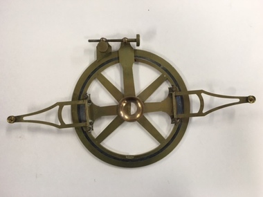
Scientific Instrument, Goniometer
... A goniometer is an instrument that either measures an angle..., gōnia, meaning angle, and metron, meaning measure. (Wikipedia ...A goniometer is an instrument that either measures an angle or allows an object to be rotated to a precise angular position. The term goniometry is derived from two Greek words, gōnia, meaning angle, and metron, meaning measure. (Wikipedia)Goniometer in a timber box. (eleven parts)galvometer, ganiometer, j. swift and sons -
 Warrnambool and District Historical Society Inc.
Instruments, Measuring tool, CLate 19th century
... for measuring angles on the vertical and horizontal planes. The two.... It is used for measuring angles on the vertical and horizontal planes ...This instrument is a folding arm protractor. It is used for measuring angles on the vertical and horizontal planes. The two folding arms have small metal support springs where they are attached to provide support and the other ends have pins with which to mark particular points. A screw mechanism on the rim allows fine tuning of plotting. Chadburn, Brothers were fine instrument makers of Sheffield making optical and nautical instruments during the 19th century. This item was donated by a local resident whose grandfather Carl Spence was a bridge builder who worked on the Warrnambool Breakwater extension c 1919. This item has scientific significance which is possibly linked via the owner to one of Warrnambool's most well known landmarks.Brass, circular instrument with fold out sections which are hinged and a movable section. The circular part is marked in degrees around the circle. Notches on inner rim at 90 degrees intervals. Chadburn ,Brothers Sheffield. Graduated scale measuring 360 degrees.warrnambool, warrnambool breakwater -
 City of Whittlesea
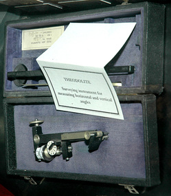
Instrument - Surveying instrument, Theodolite
... Surveying instrument for measuring horizontal and vertical... instrument in box Surveying instrument for measuring horizontal ...Surveying instrument for measuring horizontal and vertical anglesmetal instrument in boxsurveying equipment -
 Flagstaff Hill Maritime Museum and Village
Container - Box
... A ship's rudder indicator is used for measuring the angle... is used for measuring the angle of slope or pitch of the vessel ...A ship's rudder indicator is used for measuring the angle of slope or pitch of the vessel. The information can be used to adjust the steering of the ship to give safe navigation. The rudder indicator transmitter once contained in this box was battery operated, according to the label inside this box. Box, wooden, used to store a battery operated Siemen's ship's rudder indicator. Made in the United Kingdom. Descriptive leaflet glued inside hinged lid. Lid secured by hooked catch. Brass latch. Metal mounting plate. Hole drilled in back. Dovetail joints. flagstaff hill, warrnambool, shipwrecked-coast, flagstaff-hill, flagstaff-hill-maritime-museum, maritime-museum, shipwreck-coast, flagstaff-hill-maritime-village, siemen's brothers london, siemen's rudder indicator box, nautical instrument for measuring pitch or slope, scientific instrument box, navigational instrument box -
 Flagstaff Hill Maritime Museum and Village
Equipment - Sextant, Late 20th Century
... is to measure the angle between an astronomical object and the horizon... objects. The primary use of a sextant is to measure the angle ...In 1941, the scientific instrument manufacturing firms of Henry Hughes & Son Ltd, London, England, and Kelvin Bottomley & Baird Ltd, Glasgow, Scotland, came together to form Kelvin & Hughes Ltd. Kelvin Company History: The origins of the company lie in the highly successful and strictly informal relationship between William Thomson (1824-1907), Professor of Natural Philosophy at Glasgow University from 1846-1899 and James White, a Glasgow optical maker. James White (1824-1884) founded the firm of James White, an optical instrument maker in Glasgow in 1850 and was involved in supplying and mending apparatus for Thomson university laboratory and working with him on experimental constructions. White was declared bankrupt in August 1861 and released several months later. In 1870, White was largely responsible for equipping William Thomson laboratory in the new University premises at Gilmore hill. From 1876, he was producing accurate compasses for metal ships to Thomson design during this period and this became an important part of his business in the last years of his life. He was also involved in the production of sophisticated-sounding machinery that Thomson had designed to address problems encountered laying cables at sea, helping to make possible the first transatlantic cable connection. At the same time, he continued to make a whole range of more conventional instruments such as telescopes, microscopes and surveying equipment. White's association with Thomson continued until he died. After his death, his business continued under the same name, being administered by Matthew Edwards (until 1891 when he left to set up his own company. Thomson who became Sir William Thomson and then Baron Kelvin of Largs in 1892, continued to maintain his interest in the business after James White's death. In 1884 raising most of the capital needed to construct and equip new workshops in Cambridge Street, Glasgow. At these premises, the company continued to make the compass Thomson had designed during the 1870s and to supply it in some quantity, especially to the Admiralty. At the same time, the firm became increasingly involved in the design, production and sale of electrical apparatus. In 1899, Lord Kelvin resigned from his University chair and became, in 1900, a director in the newly formed limited liability company Kelvin & James White Ltd which had acquired the business of James White. At the same time Kelvin's nephew, James Thomson Bottomley (1845-1926), joined the firm. In 1904, a London branch office was opened which by 1915 had become known as Kelvin, White & Hutton Ltd. Kelvin & James White Ltd underwent a further change of name in 1913, becoming Kelvin Bottomley & Baird Ltd. Hughes Company History: Henry Hughes & Sons were founded in 1838 in London as a maker of chronographic and scientific instruments. The firm was incorporated as “Henry Hughes & Sons Ltd” in 1903. In 1923, the company produced its first recording echo sounder and in 1935 a controlling interest in the company was acquired by S Smith & Son Ltd resulting in the development and production of marine and aircraft instruments. Following the London office's destruction in the Blitz of 1941, a collaboration was entered into with Kelvin, Bottomley & Baird Ltd resulting in the establishing “Marine Instruments Ltd”. Following the formal amalgamation of Kelvin, Bottomley & Baird Ltd and Henry Hughes & Sons Ltd in 1947 to form Kelvin & Hughes Ltd. Marine Instruments Ltd then acted as regional agents in the UK for Kelvin & Hughes Ltd who were essentially now a part of Smith's Industries Ltd founded in 1944 and the successors of S. Smith & Son Ltd. Kelvin & Hughes Ltd went on to develop various marine radar and echo sounders supplying the Ministry of Transport, and later the Ministry of Defence. The firm was liquidated in 1966 but the name was continued as Kelvin Hughes, a division of the Smiths Group. In 2002, Kelvin Hughes continues to produce and develop marine instruments for commercial and military. G. Falconer Company History: G Falconer (Hong Kong Ltd) appear to have had a retail presence in Hong Kong since 1885, according to the company website, and currently have a shop in the Peninsula Hotel. G Falconer was the Hong Kong selling agent for several British companies. Ross Ltd of 111 New Bond St London was one and the other was Kelvins Nautical Instruments. Falconers were primarily watchmakers, jewellers and diamond merchants.They were also agents for Admiralty Charts, Ross binoculars and telescopes, and sold English Silverware and High Class English Jewellery. In 1928 the company was operating from the Union Building opposite the Hong Kong general post office. It is unclear if the item is an original Sextant made by Kelvin prior to his amalgamation with Henry Hughes & Sons in 1941 as Kelvin appears to have only made compasses up to this date. If the Sextant can be established that it was made by Kelvin then it is very significant and a rare item made for and distributed through their Hong Kong selling agents G Falconer Ltd. There are many Sextants advertised for sale stating "Kelvin & Hughes 1917 model sextant". These can be regarded as replicas as the company was not formed until 1941 and production of marine instruments was not fully under way until after the war in 1947. Further investigation needs to be undertaken to accurately determine the provenance of this item. As the writer currently has the impression that the subject object was possibly made by Kelvin and Hughes in the mid to late 20th century or is a replica made by an unknown maker in the late 1970s. Purchased as an exhibition prop for the Flagstaff Hill collection. The Sextant is a brass apparatus with filters and telescope lens, and comes with a wooden felt lined storage box. It is a doubly reflecting navigation instrument that measures the angular distance between two visible objects. The primary use of a sextant is to measure the angle between an astronomical object and the horizon for the purposes of celestial navigation.G Falconer and Co. Hong Kong (retailers of nautical equipmentflagstaff hill, warrnambool, shipwrecked-coast, flagstaff-hill, flagstaff-hill-maritime-museum, maritime-museum, shipwreck-coast, flagstaff-hill-maritime-village, sextant, kelvin & hughes ltd, hong kong, navigational instrument, g falconer, mariner's quadrants -
Federation University Historical Collection
Equipment - Scientific Instrument, T. Cooke & Sons Ltd, Theodolite, early 1900s
... The theodolite is used in surveying and measures vertical... in surveying and measures vertical and horizontal angles. Placed ...The theodolite is used in surveying and measures vertical and horizontal angles. Placed on a tripod, it is used to find angles in road building, tunnel alignment and other civil engineering work. The theodoliteTheodolite with four levelling screws. External focusing.ballarat school of mines, surveying, engineering, cooke, theodolite, scientific instrument -
 Flagstaff Hill Maritime Museum and Village
Instrument - Navigational Sextant, 1882-1890
... used. The primary use was to measure the angle between... was to measure the angle between an astronomical object and the horizon ...A sextant is an astronomical instrument used to determine latitude and longitude at sea by measuring angular distances, especially the altitudes of the sun, moon, and stars. It is a doubly reflecting navigation instrument and used mainly by sailors to measure the angular distance between two visible objects. The name comes from the Latin sextans, or “sixth part of a unit,” because the sextant’s arc can be 60° or 120° of a circle depending on the model used. The primary use was to measure the angle between an astronomical object and the horizon for the purposes of celestial navigation. The estimation of this angle is known as sighting or shooting the object, or taking a sight. This angle and the time when it was measured is used in order to determine Greenwich Mean Time and hence longitude. Sighting the height of a landmark on land can also give a measure of distance from that object. History: The development of the sextant was as an improvement over the octant, an instrument designed to measure one's latitude. The octant was first implemented around 1731-present but can only measure angles up to 45°. As larger angles were needed to allow the measurement of lunar objects - moon, stars and the sun - at higher angles, the octant was superseded by the sextant. The sextant is a similar instrument but better made and allows larger angles from 60° to 120°. This improvement allows distances to be accurately calculated thereby giving longitude when used with a chronometer. The sextant was derived from the octant in 1757, eventually making all previous instruments used for navigational positioning obsolete. The sextant had been attributed to by John Hadley (1682–1744) and Thomas Godfrey (1704–1749), but reference to the sextant was also found later in the unpublished writings of Isaac Newton (1643–1727). Earlier links can be found to Bartholomew Gosnold (1571–1607) indicating that the use of a sextant for nautical navigation predates Hadley's implementation. In 1922, the sextant was modified for aeronautical navigation by Portuguese navigator and naval officer Gago Coutinho. It should be noted that the octant and quadrant are in the same family as they were, and all are, regarded as sextants. The sextant is representative of it's type and although not fully complete it demonstrates how 18th,19th and 20th century mariners determined their latitude and longitudinal to determine their position on a chart, allowing them to navigate there way across the world's oceans. It also demonstrates the skill and workmanship of the early instrument makers that operated scientific instrument businesses from London and other areas of England to provide most of the navigational instrumentation used by commercial and military navies of the time.Sextant with square, fitted box of polished wood, "Hezzanith" brand. Box contains many parts for the sextants use. On certificate "Heath & Co, London. Sextant Number Y 822". Catch on lid "DEFIANT LEVER" and "PATENT NUMBER 187.10". Maker's certificate is attached to the inside of the box.flagstaff hill, warrnambool, shipwrecked-coast, flagstaff-hill, flagstaff-hill-maritime-museum, maritime-museum, shipwreck-coast, flagstaff-hill-maritime-village, sextant box, sextant, hezzanith, heath & co, navigational instrument, george wilson heath, astronomical instrument, instrument manufacturers, scientific instrument, navigation, celestial navigation, octant, quadrant, lunar navigation -
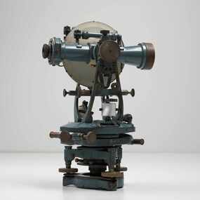 City of Greater Bendigo - Civic Collection
Instrument - Theodolite, Cooke, Troughton & Simms, c 1940
... Theodolites are a highly accurate instrument that measures... accurate instrument that measures angles between designated visible ...Theodolites are a highly accurate instrument that measures angles between designated visible points in the horizontal and vertical planes. The theodolite has a long history, with the term first found in 1571 in a surveying textbook 'A geometric practice named Pantometria' by Leonard Digges. (source https://en.wikipedia.org/wiki/Theodolite). Cooke Troughton & Simms began when John Troughton starting selling products in Fleet Street, London in 1782. He went into partnership with his brother Edward in 1807 who expanded the business considerably. William Simms, a former apprentice with the company was taken as a partner and then manager after Edward died in 1835 and the company became Troughton & Simms. By 1887 the company was able to produce all the parts necessary for their instruments and the company employed nearly 200 people and was one of the most well respected firms of instrument makers of the 1800's. James Simms, son of William who had inherited the company died in 1915 and the company was turned into a limited liability company by his two sons William and James. Things however were not so easy for the two sons and in 1922 the business was brought out by their rival T. Cooke & Sons becoming Cooke, Troughton & Simms. Theodolites are used by surveyors as part of their everyday work and although there is no specific information regarding the provenance of this particular one it is assumed it was used locally by the City of Bendigo and / or the Lands Department.A grey theodolite no 39161 made by Cooke, Thoughton & Simms. Various moving parts showing signs of extensive use particularly on the uprights on the main body and around knobs and dials where the paint is worn back to brass.Cooke, Thoughton & Simms Ltd / York. England / No 39161. Sticker; DPS - Asset No / (barcode) / 0010173city of greater bendigo administration item, lands and survey department bendigo -
 Flagstaff Hill Maritime Museum and Village
Octant, Late 18th to mid-19th century
... . The primary use of an Octant is to measure the angle between... of a circle. The primary use of an Octant is to measure the angle ...An Octant is a doubly reflecting navigation instrument used primarily by sailors to measure the angular distance between two visible objects and was a forerunner of the sextant. The name comes from the Latin octo, or “one-eighth of a circle,” for the Octant’s arc which spans 45°, or one-eighth of a circle. The primary use of an Octant is to measure the angle between an astronomical object and the horizon for the purposes of celestial navigation. The estimation of this angle is known as sighting or shooting the object, or taking a sight. The angle, and the time when it was measured, can be used to calculate a position line on a nautical chart (latitude), for example, sighting the Sun at noon or Polaris at night (in the Northern Hemisphere) gives an angle by which the latitude can then be estimated. Sighting the height of a landmark on land can also give a measure of distance. History: The principle of the Octant as an instrument to measure ones latitude was first implemented around 1742-present but was superseded by the improvement of the octant to a sextant, a very similar instrument, better made and able to measure bigger angles 120°, allowing the measurement of Luna distances to give longitude when used with an accurate chronometer. The sextant started to appear around 1730 and had been attributed to by John Hadley (1682–1744) and Thomas Godfrey (1704–1749), but reference to the sextant was also found later in the unpublished writings of Isaac Newton (1643–1727). Earlier links can be found to Bartholomew Gosnold (1571–1607) indicating that the use of a Sextant for nautical navigation predates Hadley's implementation. In 1922, the sextant was modified for aeronautical navigation by Portuguese navigator and naval officer Gago Coutinho. Henry Hemsley was a lesser-known instrument maker and optician working in London in the late 17th and early 18th century. However, it should be noted that there were two Henry Hemsley opticians and instrument makers around this period. (Henry Hemsley 1, 1786-89, who had premises at 85 Fleet St London and Henry Hemsley 2, 1828-56), whose workshop was at 135-138 Radcliff Highway London. Therefore, based on the inscribed workshop address Henry Hemsley 2 is responsible for making this example.The octant is representative of its type and although not fully complete it demonstrates how 18th and 19th-century mariners determined their latitude on a chart to navigate their way across the world's oceans in the 18th and 19th century. It also demonstrates the skill and workmanship of the early instrument makers that operated from London at this time and provided most of the navigational instrumentation use by commercial and military navies of the time.Octant, ebony wooden frame and handle. Scale is missing from recess in frame. "H. Hemsley 135-138 Ratliff Highway, London", no box"H. Hemsley 135-138 Ratcliff Highway, London"flagstaff hill, warrnambool, shipwrecked-coast, flagstaff-hill, flagstaff-hill-maritime-museum, maritime-museum, shipwreck-coast, flagstaff-hill-maritime-village, navigation, navigational instrument, instrument used for navigation, sextant, henry hemsley, instrument maker, london, octant -
Clunes Museum
MICROSCOPE, c1880
... objective lens with adjustable frame and base .2 Graticule Measure... objective lens with adjustable frame and base .2 Graticule Measure ....1 Microscope - Binocular Binomax Model No. 10303 with 2 x objective lens with adjustable frame and base .2 Graticule Measure Eye Piece .3 Medium Magnify Eye Piece .4 Angular Measure Eye Piece .5 Angle 45degree Optical Path AttachmentBeck Londonbeck, microscope, binoculars, binomax 10303 -
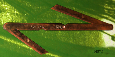 Flagstaff Hill Maritime Museum and Village
Tool - Bevel gauge, Mid-to-late 20th century
... , to measure, set angles and transfer angles. The shipwright’s tools... tool, to measure, set angles and transfer angles ...The double bevel gauge is used as a drawing tool, to measure, set angles and transfer angles. The shipwright’s tools on display in the Great Circle Gallery are connected to the maritime history of Victoria through their past owner, user and donor, Laurie Dilks. Laurie began his career as a shipwright in the mid-1900s, following in the wake of the skilled carpenters who have over many centuries used their craft to build and maintain marine vessels and their fittings. You can see Laurie’s inscription on the tool called a ‘bevel’. Laurie worked for Ports and Harbours, Melbourne, for over 50 years, beginning in the early 1960s. He and a fellow shipwright inscribed their names on a wheelhouse they built in 1965; the inscription was discovered many decades later during a repair of the plumbing. Many decades later Laurie worked on the Yarra moving barges up and down the river and was fondly given the title ‘Riverboat Man’ His interest in maritime history led him to volunteer with the Maritime Trust of Australia’s project to restore and preserve the historic WWII 1942 Corvette, the minesweeper HMAS Castlemaine, which is a sister ship to the HMAS Warrnambool J202. Laurie Dilks donated two handmade displays of some of his tools in the late 1970s to early-1980s. The varnished timber boards displayed the tools below together with brass plaques. During the upgrade of the Great Circle Gallery Laurie’s tools were transferred to the new display you see there today. He also donated tools to Queenscliffe Maritime Museum and Clunes Museum.The shipwright’s tools on display in the Great Circle Gallery are connected to the maritime history of Victoria through their past owner, user and donor, Laurie Dilks. Laurie began his career as a shipwright at Ports and Harbours in Melbourne in the mid-1900s, following in the wake of the skilled carpenters who have over many centuries used their craft to build and maintain marine vessels and their fittings.This double bevel gauge has three lengths of flat brass that swivel at the joints. The long piece has curved ends and indented arcs, one on each side, along the length. The short pieces have diagonal ends. The centre length has a hole through the middle. The short pieces have a screw with its head above the flat brass. The tool has an inscription. It once belonged to shipwright Laurie Dinks.Bevel marked "L DILKS" "G. M."flagstaff hill, warrnambool, great ocean road, shipwreck coast, maritime museum, maritime village, shipwright, carpenter, shipbuilding, ship repairs, hand tool, equipment, ship maintenance, cooper, tool, marine technology, bevel, drawing tool, measuring tool, laurie dilks, l dilks, port and harbours melbourne -
 Flagstaff Hill Maritime Museum and Village
Octant, Mid to late 19th Century
... An octant is an astronomical instrument used in measuring... instrument used in measuring the angles of heavenly bodies ...An octant is an astronomical instrument used in measuring the angles of heavenly bodies such as the sun, moon and stars at sea in relation to the horizon. This measurement could then be used to calculate the altitude of the body measured, and then the latitude at sea could also be calculated. The angle of the arms of an octant is 45 degrees, or 1/8 of a circle, which gives the instrument its name. Two men independently developed the octant around 1730: John Hadley (1682–1744), an English mathematician, and Thomas Godfrey (1704–1749), a glazier in Philadelphia. While both have a legitimate and equal claim to the invention, Hadley generally gets the greater share of the credit. This reflects the central role that London and the Royal Society played in the history of scientific instruments in the eighteenth and nineteenth century's. There were also two others who are attributed to having created octanes during this period, Caleb Smith, an English insurance broker with a strong interest in astronomy (in 1734), and Jean-Paul Fouchy, a mathematics professor and astronomer in France (in 1732) In 1767 the first edition of the Nautical Almanac tabulated lunar distances, enabling navigators to find the current time from the angle between the sun and the moon. This angle is sometimes larger than 90°, and thus not possible to measure with an octant. For that reason, Admiral John Campbell, who conducted shipboard experiments with the lunar distance method, suggested a larger instrument and the sextant was developed. From that time onward, the sextant was the instrument that experienced significant development and improvements and was the instrument of choice for naval navigators. The octant continued to be produced well into the 19th century, though it was generally a less accurate and less expensive instrument. The lower price of the octant, including versions without a telescope, made it a practical instrument for ships in the merchant and fishing fleets. One common practice among navigators up to the late nineteenth century was to use both a sextant and an octant. The sextant was used with great care and only for lunar sightings while the octant was used for routine meridional altitude measurements of the sun every day. This protected the very accurate and pricier sextant while using the more affordable octant for general use where it performs well. The invention of the octant was a significant step in providing accuracy of a sailors latitude position at sea and his vessels distance from land when taking sightings of land-based landmarks.Octant with metal handle, three different colored shades are attached, in wooden wedge-shaped box lined with green felt. Key is attached. Two telescope eyepieces are in box. Some parts are missing. Oval ink stamp inside lid of box, scale is graduated to 45 degrees. Ink stamp inside lid of box "SHIPLOVERS SOCIETY OF VICTORIA. LIBRARY"instrument, flagstaff hill, warrnambool, shipwrecked coast, flagstaff hill maritime museum, maritime museum, shipwreck coast, flagstaff hill maritime village, great ocean road, octant, navigation, nautical instrument, navigation instrument, john hadley, sextant, astronomical instrument -
 Bendigo Military Museum
Photograph - Johnson Ground Elevation Meter (JGEM) Survey Vehicle - Army Survey Regiment, Fortuna, Bendigo, c1960s
... apparatus which measures the instantaneous angle of inclination... datum for the angle measurement. The wheel provided the velocity ...This is a set of 16 photograph of the Royal Australian Survey Corps’ Johnson Ground Elevation Meter (JGEM) Survey Vehicle taken at the Army Survey Regiment, Fortuna, Bendigo. The JGEM vehicle was extensively used by RA Svy within Australia from the late 1960s. A limited number of Ground Elevation Meter (GEM) station wagon type vehicles were manufactured by General Motors Corporation (GMC) in the USA for the United States Geological Survey, Canada’s mapping agencies, RA Svy and National Mapping (Natmap). The GEM was a four-wheel drive, four-wheel steer vehicle. Four-wheel steering was necessary to avoid systematic errors caused by non-tracking of front and rear wheels on conventionally steered vehicles. The manufacturer substituted the rear axle with a front axle and connected them to form the four-wheel steering mechanism. The two Australian GEM vehicles, referred to as Johnson GEMs (JGEMs) were converted into right-hand drive. After delivery in 1964, acceptance Natmap and RA Svy testing and operator training was undertaken at the Army's School of Military Survey located at Balcombe, Victoria. A small fifth wheel was mounted on a cantilever arm suspension midway between the front and rear wheels on the right side of the vehicle. It was lowered to and raised from its operating position by use of a constant pressure air cylinder. A telescopic bar, suspended between the front and rear axles, provided the reference datum for the angle measurement. The wheel provided the velocity or distance signal through a pulse generator system. A sensitive pendulum mounted on this bar provided the angle measurement for each minute distance traversed. The JGEM contained electromechanical instruments used to determine relative elevations, by trigonometric principles, along a traversed path. These relative elevations were obtained through apparatus which measures the instantaneous angle of inclination of the road and the instantaneous velocity of the meter along such a path. Road routes over which the JGEM operated were planned so that each started and ended as near as practicable to an existing point of known elevation (formally referred to as a level traverse bench mark). The difference in height from the bench mark and the road surface alongside the JGEM’s fifth wheel was measured with a level and staff. Along each route, mapping control photo reference points where new elevation values were required were identified on aerial photographs. Under favourable conditions it was possible to survey as much as 160km in an ordinary working day. The first of RA Svy’s JGEM operations was undertaken in 1:250,000 scale map areas of Queensland. CPL John Hook was the JGEM’s main operator in the early 1970s undertaking operations covering 1:250,000 scale map blocks over northern Victoria and central NSW, each requiring 36 points (9 runs of photography and 4 points across. SPR Lyn Thompson and SPR Bob McDonagh teamed with CPL Hook on some of these JGEM operations. When RA Svy was integrated into the Royal Australian Engineers in 1996, the JGEM vehicle with the Survey Corps collection was donated to its museum. It is believed to be the last of the original manufactured fleet in existence. The JGEM has undergone extensive refurbishment to achieve roadworthiness and is currently housed at The Australian Army Museum of Military Engineering, Hoslworthy Barracks, NSW. It can be viewed by making an appointment with the museum’s curator.This is a set of 16 photograph of the Royal Australian Survey Corps’ Johnson Ground Elevation Meter (JGEM) Survey Vehicle taken at the Army Survey Regiment, Fortuna, Bendigo. The photographs were on 35mm slide film and were scanned at 96 dpi. They are part of the Army Survey Regiment’s Collection. .1) - Photo, colour, c1960s, Johnson Ground Elevation Meter (JGEM) Survey Vehicle .2) - Photo, colour, c1960s, JGEM instrumentation, on-board computer. .3) - Photo, colour, c1960s, JGEM instrumentation. .4) - Photo, colour, c1960s, JGEM instrumentation, on-board computer. .5) - Photo, colour, c1960s, JGEM tyre pressure controller .6) - Photo, colour, c1960s, JGEM rear doors, SGT Geoff Briggs. .7) - Photo, colour, c1960s, JGEM 5th wheel distance/angle measurement device in lowered position, SGT Geoff Briggs. .8) - Photo, colour, c1960s, JGEM 5th wheel distance/angle measurement device in lowered position. .9) & .10) - Photo, colour, c1960s, JGEM tyre pressure system, SGT Geoff Briggs. .11) - Photo, colour, c1960s, JGEM tyre pressure system. SGT Geoff Briggs. .12) - Photo, colour, c1960s, JGEM levelling scope, levelling staff, unidentified technicians. .13) & .14) - Photo, colour, c1960s, JGEM levelling scope, unidentified technician. .15) & .16) - Photo, colour, c1960s, probably survey operation adjusted height plotted on block base sheet. .1P to .16P - Some of the equipment is annotated on the frame of the 35mm slides.royal australian survey corps, rasvy, army survey regiment, army svy regt, fortuna, asr, surveying -
 Flagstaff Hill Maritime Museum and Village
Head Rod, Dring & Fage, c. 1901
The Australian Customs Service, Melbourne, donated a set of gauging instruments, and Port Fairy Customs donated another instrument, the Sike’s Hydrometer, to Flagstaff Hill Maritime Village, all of which were no longer required. However these ullaging tools were in use for many years by Customs officials, called Gaugers. Ullaging is a term describing the measurement of the amount of liquid remaining in a container of spirits such as a cask or barrel. It can also measure the free space or head space remaining. The primary role of customs officers in Victoria was to calculate the tariff or excise duty payable on goods imported into Victoria. (Excise duty is a tax on goods produced within a country, and customs duty is imposed on imports.) Customs officers spent a great deal of their time measuring and weighing goods, and then calculating the amount of duty to be paid by the importer. The tariffs for different products varied, and officers consulted published lists. Calculating the duty payable on a barrel of brandy was a detailed task. The gauger had to measure the barrel to determine its volume. Barrels were irregular in shape, and finding the volume required several measurements and checking tables of figures. Alcoholic content was then measured with a hydrometer. The duty paid varied according to the alcoholic strength of the spirits. Uniform national customs and excise duties were operative in Australia from October 1901. These tools were still being used in Australia in the 1950’s. The Federal Government still imposes excise taxes on goods such as cigarettes, petrol, and alcohol. The rates imposed may change in February and August each year in response to changes in the consumer price index. ULLAGING TOOLS (1) Head Rod - this instrument measures the diameter of the heads (top and bottom ends) of a cask or barrel. The shaped brass pieces on the head rod enable the diameter of a barrel to be measured inside the chimes at the head end. The slide rule could then be used to calculate the internal volume of the barrel. On the reverse side is a set of ullaging scales, used like those on any ullaging rule, to calculate the volume of liquid in a partially filled barrel. (2) Bung Rod – this instrument measures the diameter of a cask or barrel when it is lying on its side. It is a rod that fits into the ‘bung’ hole of a cask and is long enough be extended to reach the opposite side of the cask. The brass sliding pointer can be moved to mark the ‘wet’ line. When the rod is removed the bung measurement can be read from the scale on the rod. (3) Long Calipers - this instrument measures the length of the cask between the heads. It has two rules sliding beside each other, each end having another piece of wood fixed firmly at right angles downwards then turned inwards at the ends so as to reach over the heads of the casks without touching the projecting ends. The centre pieces enable it to extend or contract, changing the distance between the two other parallel sides, the distance they are apart being shown by the rule on the sliding pieces. (4) Cross Calipers – this instrument is used to take the bung diameters of casks, or "the Cross " as it is called. This instrument has two rules sliding beside each other, each end having another piece of wood fixed firmly at right angles downwards, together forming a 3 sides of a rectangle with the centre pieces enabling it to extended or contracted, changing the distance between the two other parallel sides, the distance they are apart being shown by a the rule on the sliding pieces. (5) Sike’s Hydrometer – this instrument is used to gauge the strength of different alcoholic spirits when fitted with the different weights in the set. Every set is individually calibrated to ensure that it meets the exact Standard Weight and Measure compliance, then every piece in that set is stamped with the same number by the Calibrator, to ensure that the measurements are taken using the same hydrometer set. [References: A Handbook of Practical Gauging, Janes Boddely Keene of H.M. Customs, 1861, F. Pitman, London; Customs Act, Volume 2, No. 1, April 1999; Old Customs House website ] Head Rod, ullaging gauge. Long wooden rod made of three joined sections, brass hook on end, sliding centre section with hook, measurements marked along each section as on a slide rule. Used for measuring diameter of heads of casks in order for Customs to calculate excise (tax) on the contentsflagstaff hill, warrnambool, shipwrecked coast, flagstaff hill maritime museum, maritime museum, shipwreck coast, flagstaff hill maritime village, great ocean road, head rod, gauging rod, ullaging rods, measuring instruments, customs tax -
 Flagstaff Hill Maritime Museum and Village
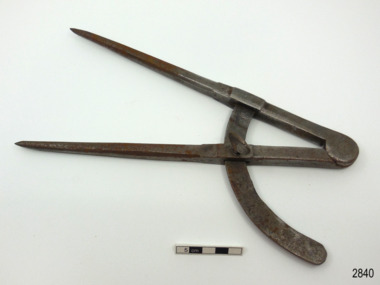
Barrel Calipers, Early 20th Century
The firm Dring and Fage were active from 1790 to 1940 in London and were manufacturers of hydrometers and mathematical instruments they became established in London in 1790 by John Dring, who was a brass worker and hydrometer maker, and William Fage. Dring and Fage manufactured also saccharometers and other instruments used to measure the strength of alcohol. These instruments were primarily used to calculate excises. They traded at various addresses in London and they were at 56 Stamford St. between 1903 and 1938. By 1850 the company was owned by Edward Hall and Edward Jenkin and in 1940 the company became Dring & Fage Ltd, trading till the 1960s.Historically, gauging has meant measuring a volume, these gauging instruments were used by Customs and Excise and manufacturers for determining the volume and contents of liquid containers. For Customs the determination and collection of duty on imported goods which has had a very long history. Chaucer was a Customs Officer as was his father and grandfather, excise was first officially introduced in 1643, with the aim of maintaining military forces raised by the English Parliament at that time. Excise was initially a duty on home produced alcoholic beverages and soap but being easily applied, spread rapidly to a wide range of goods including imports of varying kinds. The government departments of Customs and Excise merged only in 1909 and it is from around this time that our instrument was made and used. The item demonstrates a long social history of the practice of Government's collecting duty on alcoholic beverages and thereby makes this item historically significant as it was used locally at Port Fairy by the ports Customs agents. Boxwood barrel calipers, wooden slide-rule with right angles at each end and brass fittings used for measuring casks length."Dring & Fage Makers to the Customs" stamped on side.flagstaff hill, warrnambool, shipwrecked coast, flagstaff hill maritime museum, maritime museum, shipwreck coast, flagstaff hill maritime village, great ocean road, customs, long calipers, excise duty, barrel calipers -
 Warrnambool and District Historical Society Inc.
Walking Stick, Mr Bendall Walking & Measuring Stick, c.1920
This walking stick, which is also a horse measurer, belonged to Atwell George Bendall, the well-known racing man, judge and handicapper in the Western District early in the 20th century. Born in the Caramut district, he was the manager of the ‘Green Hills’ estate at Winslow, a property owned by his father who also operated a livery and coach service at Caramut. When his father died Bendall carried on the family business until the end of the 19th century when he went to live in Warrnambool. A lover of horses, Bendall was an amateur rider of note and an owner of several racehorses. He also took a keen interest in coursing and owned and bred many successful dogs. In Warrnambool he took an interest in trotting and owned several trotters. For the last sixteen years of his life Atwell Bendall was a handicapper for most of the Western District race clubs and his keen judgment and knowledge of horses were greatly admired and appreciated. He was also a judge at agricultural shows and other horse events and this is probably where he was made use of this horse-measuring walking stick. He died in 1922. This is a most significant item as it belonged to the prominent early 20th century horse racing identity in the Western District – Atwell Bendall. It is also of general historical interest as an ingenious object – a walking stick doubling as a horse measurer. This is a mottled brown-coloured wooden walking stick, slightly tapered and with seven segments. It has a wooden knob at the top curved and indented in an acorn shape. The knob has silver coloured nails or tacks driven into the raised sections. The knob lifts out and is actually a wooden ruler with silver casing at the top of the ruler. Also at the top of the ruler, at a right angle to the ruler, is a lift-out metal piece which has a spirit level at the top end and this metal piece is used to rest on the horse to estimate its measurement in hands. There is a leather strap near the top of the walking stick for attachment to the wrist and a gold metal cap at the bottom of the stick. A silver band near the top of the stick has an inscription. ‘A G. Bendall Warrnambool’ atwell bendall, history of horse racing in the western district, history of warrnambool -
 Numurkah & District Historical Society
Carpentry Tools & Storage Box
These carpentry items were owned and used by Archibald (Mick) Blackley, a local long-time resident of Numurkah. Born 1912 in Numurkah, Mick was the son of Archibald (Senior) and Grace Blackley, also residents of Numurkah. Archie Senior was a carter, horse-breaker, conducted a livery stable and worked at Brown Corke & Co for a number of years. Archie also served in the Veterinary Corps in WW1. Some of the tools donated belonged to Archie Senior eg wooden hand planes. Mick Blackley used his dad’s tools (and also added some of his own) when he worked in various carpentry jobs during the 1930’s and 1940’s. One particular carpentry job was during the depression when Mick relocated to the Wonthaggi State Coal Mines building stables for the horses, and also completing some building works inside the mines. Returning to Numurkah, Mick joined a Mr Murray as carpenter and painter to build and repair houses. He then joined another builder for 4 years (We think this was Jim Tuttle). Mick then went on to work at the Butter Factory (originally called Holdenson & Nielsen) where some of his carpentry skills were still used. Item list: • Wooden box for carpentry tools • 1 x steel pliers • 2 x wooden hand planes • 1 x tin snips • 1 x wooden spirit level in canvas bag • 1 x small wooden spirit level • 5 x wooden handled hand-saws • 1 x wooden handled right- angle square • 1 x wooden handled tenon-saw • 1 x steel plumbers wrench • 1 x wooden handled hedge-clippers • 1 x cloth & leather measuring tape • 1 x wooden mallet • 1 x narrow wooden plane • 1 x plastic handled hand-saw • 1 x plane blade sharpening stone • 1 x brace hand drill • 1 x compass for marking wood • 1 x cold chisel • 1 x set of various chisels and hand drill bits in a canvas bag • 1 x steel sike • Various other drill bits, chisels, files • 1 x wooden handled trowel • • 2 x steel garden secateurs • carpentry, building, wood, tools, planes, levels, chisels, hammers, saws, drills, drill bits -
 Flagstaff Hill Maritime Museum and Village
Instrument - Compass, late 19th to early 20th century
This large compass is well made. It is now pitted and scratched, indication much use. Compasses were used to measure and mark out the head of the barrel by coopers. Very large compasses were used by block, spar and pump makers to help shave off angles left by axes and other tools on mast sides. Also they were used by blacksmiths in their work draftsmen, carpenters, engineers and navigators.This compass is an example of a drawing instrument that could have been used in the 19th and early 20th century by coopers and blacksmiths as well as navigators and ship smiths.Compass; large metal compass, 90-degree angle, two pointed arms hinged at the top. Inscription on the top of one arm.Stamped into the metal " J J E " ( or J J F )flagstaff hill, warrnambool, maritime village, maritime museum, flagstaff hill maritime museum & village, shipwreck coast, great ocean road, compass, drawing instrument, measuring instrument, scientific instrument, draftsman, technical drawing, navigation, engineering, blacksmith, cooper, plumber -
 Flagstaff Hill Maritime Museum and Village
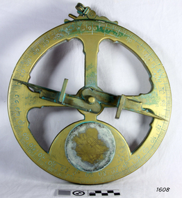
Instrument - Mariner's astrolabe, Late 20th century
This representative example demonstrates a mariner’s astrolabe. Historical examples are rare. There are less than one hundred known to exist and most of these have been recovered from shipwrecks, many from Spanish and Portuguese vessels. An astrolabe is a measuring device once used to navigate the seas by observing the sun and stars to measure their altitude. The measurement of altitude could then be used to calculate the ship’s latitude but at that time in history there was no means of measuring longitude. The body of the navigational astrolabe was cast brass and much heavier, and less complicated than the variety used on land. The heavier weight and cut-away shape reduced the effect of the wind and waves when trying to use it at sea. A mariner’s astrolabe or ‘star finder’ is a simplified version than that used by Arabic astronomers to find the altitude of the sun and stars above the horizon, and time of the sunrise and sunset. It is a forerunner to the quadrant, octant and sextant and was popular for about 200 years over the 1500s and 1600s to find the latitude of a ship at sea. The user held the astrolabe at eye level and, usually with assistance, aligned the stars through the two small sights (pinnules), then read the altitude indicated by the pointer on the arm. It could also be used to sight the sun by holding it lower down, aiming it at the sun, and adjusting it until the sun shone through both pinnules. This astrolabe is an example used to demonstrate the mariner’s astrolabe, which was navigational tool of the 1500s and 1600s, in the time before longitude was able to be determined. It is a forerunner to modern navigation technology. Mariner’s astrolabe – a representative example. A gold painted, disc shaped object with cut outs and revolving arm in centre. The arm has two sights attached at right angles. The top has a ring attached. Measurements are marked in degrees in a circular scale around outer edge.flagstaff hill, warrnambool, maritime village, maritime museum, flagstaff hill maritime museum & village, shipwreck coast, great ocean road, navigation instrument, navigation tool, navigation, astrolabe, mariner’s astrolabe, measure latitude, measure altitude, arabic navigation, measuring device, star finder, astronomy, marine tool, marine instrument -
 Flagstaff Hill Maritime Museum and Village
Functional object - Telescope, 1752-1900
The discovery of the first telescope in 1608 can be attributed to Hans Lippershey of the Netherlands when he discovers that holding two lenses up some distance apart bring objects closer. He applies for a patent on his invention and this becomes the first documented creation of a telescope. Then in 1668, Newton produces the first successful reflecting telescope using a two-inch diameter concave spherical mirror. This opened the door to magnifying objects millions of times far beyond what could ever be obtained with a lens. It wasn’t until 1729 that Chester Moor Hall develops an achromatic lens (two pieces of glass with different indices of light refraction combined produce a lens that can focus colours to almost an exact point resulting in much sharper images but still with some distortion around the edges of the image. Then in 1729 Scottish instrument maker James Short invents the first parabolic and elliptic, distortion-less mirror ideal for reflecting telescopes. We now come to John Dollond who improves upon the achromatic objective lens by placing a concave flint glass lens between two convex crown glass lenses. This had the effect of improving the image considerably. Makers Information: John Dollond (1707-1761) London England he was a maker of optical and astronomical instruments who developed an achromatic (non-colour distorting) refracting telescope and practical heliometer. A telescope that used a divided lens to measure the Sun’s diameter and the angles between celestial bodies. The son of a Huguenot refugees Dollond learned the family trade of silk weaving. He became proficient in optics and astronomy and in 1752 his eldest son, Peter joined his father in an optical business, in 1753 he introduced the heliometer. In the same year, he also took out a patent on his new lenses. He was elected a fellow of the Royal Society in May 1761 but died suddenly in November and his share in the patent passed to his son Peter. In subsequent squabbles between Peter and the many London opticians who challenged his patent, Peter’s consistent position was that, whatever precedents there may have been to his achromatic lenses, his father had independently reached his practical technique on the basis of his theoretical command of Newtonian optics. As a result of maintaining his fathers patent, Dollond s became the leading manufacturer of optical instruments. For a time in the eighteenth and nineteenth century the word 'Dollond' was almost a generic term for telescope rather like 'Hoover; is to vacuum cleaner. Genuine Dollond telescopes were considered to be amongst the best. Peter Dollond (1731-1820) was the business brain behind the company which he founded in Vine Street, Spitalfields in 1750 and in 1752 moved the business to the Strand London. The Dollonds seem to have made both types of telescopes (reflecting and refracting), possessing the technology to produce significant numbers of lenses free of chromatic aberration for refracting telescopes. A Dollond telescope sailed with Captain Cook in 1769 on his voyage to observe the Transit of Venus. Thomas Jefferson and Admiral Lord Nelson were also customers of the Dollonds. Dollond & Co merged with Aitchison & Co in 1927 to form Dollond & Aitchison, the well-known high street chain of opticians, now fully part of Boots Opticians. They no longer manufacture but are exclusively a retail operation. John Dollond's experiments in optics and how different combinations of lenses refract light and colour gave a better understanding of the divergent properties of lenses. That went on to inform and pave the way for the improvement of our understanding of optics that are represented today. Dollond was referred to in his time as the "Father of practical optics" as a leader in his field he received many prestigious awards. The telescope in the collection is a good example of one of Dollonds early library telescopes and its connection with one of England's 18th-century pioneers in optical development is in itself a significant and an important item to have within the collection. One tube ships day & Night Telescope brass inner tube with timber main tube covered in leather. Unavailable to inspect Inscriptions to determine authenticity.flagstaff hill, warrnambool, shipwrecked-coast, flagstaff-hill, flagstaff-hill-maritime-museum, maritime-museum, telescope, dolland, shipwreck-coast, flagstaff-hill-maritime-village, royal national life boat institution -
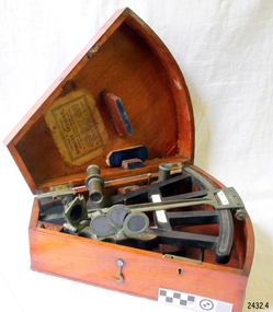
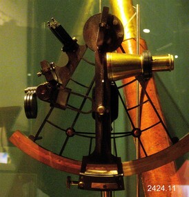
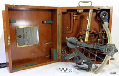
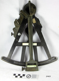
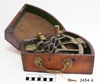
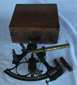 Queenscliffe Maritime Museum
Instrument - Sextant in wooden box
... used to measure angles between beacons or points ...Sextant used by J P Larken, Government Marine SurveyorThe sextant has been the primary position fixing tool of the marine surveyor for 200 years used to measure angles between beacons or points for hydrographic surveys. A sextant in its own wooden box.On inside box lid; 'A. E. Parson surveying and scientific instrument maker, Queen Street, Melbournesextant, jp larken, marine surveyor -
 Myrtleford and District Historical Society
Inclinometer, Early 20th Century
Provenance not clear. Leather case has 'MMBW' inscribed in black pen, indicating an association with Melbourne Metropolitan Board of Works. Item has been in the possession of Terry McCormack since 1972Hand held brass pocket inclonometer level, circa 1920. Leather case for safe storage. Semi circular graduated dial with 90 degree vernier scale with a small (20mm) magnifying glass to aid reading the vernier scale. Above the body, mounted at the rear of the graduated dial, is a spirit level tube which is tilted by finger movement to the milled hand wheel. The height to be determined is sighted through the instrument eyepiece and the bubble tube is tilted until the bubble, viewed in the mirror inside the sighting tube, is brought level with the graticule sighted at the top of the subject object. An angle is thus obtained and by measuring the distance on the ground to the object, trigonometry can be applied to determine the height of the object.Herga & Co. BRISBANE. Made in England -
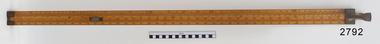
 Forests Commission Retired Personnel Association (FCRPA)
Basal Area Angle Gauge
Foresters usually measure the diameter of trees at Breast Height – traditionally 4 foot, 6 inches – now 1.3 m – which is termed Diameter Breast Height Over Bark (DBHOB). Basal Area is the cross section of the tree trunk at breast height, and the sum for the stand or group of trees is expressed square feet per acre (after 1973 it was expressed in square metres per hectare). Lots of skinny trees, or a few fat ones, can have the same Basal Area, but when combined with the number of stems, Basal Area is a good indicator of stand density. Two common methods are used to measure of Basal Area – fixed area plots and angle count sampling. 1. Fixed area plots require setting out a small area, commonly 50 m x 20 m, and measuring all the trees at breast height, and doing some quick sums. 2. Angle count sampling involves a simple sweep of the forest from a fixed sampling point using a relascope, dendrometer sight, angle gauge, or glass wedge prism. This wooden builders ruler has been shaped at one end to create a shallow angle (usually less than 3 degrees). Standing in one spot, a sweep is made with the wedge held to the eye, and trees are counted as either “in” or “out”. The number of trees is multiplied by conversion factor of the wedge (10 in this case) to estimate basal area. It’s very quick and effective.Basal Area Angle Gauge The two ends fold up and one end (on the right) has been reduced in width to create a shallow angle for the viewer Home made by cutting down a wooden builder's ruler Many forestry students made their own Basal Area Angle Gauges and its thought this may be oneforest measurement -
 Bendigo Military Museum
Photograph - Royal Australian Survey Corps Surveyors in the Field – Project Cutlass, New Guinea, 1956 – 1957
... theodolites to observe horizontal and vertical angles and chains... theodolites to observe horizontal and vertical angles and chains ...This is a set of 23 photographs of surveyors and support staff in the field undertaking tasks in New Guinea 1956 – 1957. The surveyors were employed in the establishment of mapping and geodetic control for Project Cutlass, the “Ship-Shore” survey of the New Ireland province. In this survey operation surveyors used theodolites to observe horizontal and vertical angles and chains to measure base line distances between survey stations. Bob Skitch shown in photo .7P was in the 2nd year of his career in the Australian Army. He achieved the rank of Lieutenant-Colonel, and his last appointment was the CO of the Army Survey Regiment from 1976 to 1980.This is a set of 23 photographs of surveyors and support staff in the field undertaking duties during Project Cutlass located in New Ireland, New Guinea 1956 – 1957. The photographs were printed on photographic paper and are part of the Army Survey Regiment’s Collection. The photographs were scanned at 300 dpi. .1) - Photo, colour, 1956. Surveyors travelling main road from Kavieng to Namatanai, New Ireland. .2) - Photo, colour, 1956. Unidentified surveyors assessing recovery of their vehicle after bridge collapsed on west side of New Ireland. .3) - Photo, colour, 1956. Unidentified surveyors assessing recovery of their vehicle after bridge collapsed over flooded creek on west side of New Ireland. .4) - Photo, colour, 1956. Survey personnel L to R: Bev Uwins, John Lambie, Bob Thompson, New Ireland. .5) - Photo, colour, 1956. Survey base camp, New Ireland. .6) - Photo, black & white, 1956-1957. Geoff Helsham with possible human remains, New Ireland. .7) - Photo, black & white, 1956-1957. Bob Skitch undertaking survey observations using Wild T2 theodolite, New Ireland. .8) - Photo, black & white, 1956-1957. Chas Beach undertaking survey observations using Wild T2 theodolite, New Ireland. .9) & .10) - Photo, black & white, 1956-1957. Kev Parker (cook) New Ireland. .11) - Photo, colour, 1957. Brian Berkery taking a break, Top Manor Island, Lihir Island Group off New Ireland. Latitude -2° 46”, Longitude 152° 40”. .12) - Photo, colour, 1957. Survey base camp L to R: Chas Beach, Bev Uwins, Feni Islands, New Ireland. Latitude -4° 05”, Longitude 153° 45”. .13) - Photo, colour, 1957. A Hous Kiap. (Kiaps, known formally as district officers and patrol officers, were travelling representatives of the British and Australian governments), New Ireland. .14) & .15) - Photo, colour, 1957. L to R: Joe Farrington, Tom Royle Bob undertaking survey observations using theodolites from an improvised timber tower, New Ireland. .16) & .17) - Photo, colour, 1957. US Army ship FS216 used for ship-to-shore triangulation docked at Rabaul, New Britain. .18) - Photo, colour, 1957. US Army ship FS216 used for ship-to-shore triangulation docked at Kavieng, New Ireland. Sight target on top of mast. .19) - Photo, colour, 1957. Survey personnel onboard US Army ship FS392, L to R: Peter Frodsham, Bob Thompson, Doc Reid, John Underwood, remainder unidentified, New Ireland. .20) - Photo, colour, 1957. Survey base line party heading ashore, New Ireland. .21) - Photo, colour, 1957. Survey personnel rowing US Army assault boat L to R: Kev Parker, Chas Beach, folded up survey beacons overhanging stern, New Ireland. .22) - Photo, colour, 1957. Les Bailey onboard US Army ship departing Rabaul, New Britain for Brisbane. .23) - Photo, colour, 1957. Ron Newman onboard US Army ship departing Rabaul, New Britain for Brisbane. Active volcano in background..1P to .23P annotated on back – ‘Operation Cutlass’, personnel names, the year and the location. royal australian survey corps, rasvy, army survey regiment, fortuna, a, army svy regt, asr, surveying